I medfør af § 1, stk. 1 og stk. 3, § 6, § 17, stk. 6, og § 32 i lov om sikkerhed til søs, jf. lovbekendtgørelse nr. 654 af 15. juni 2010, fastsættes efter bemyndigelse:
Til sikring af skibsfarten og miljøet i Sundet samt lufttrafikken til og fra Københavns Lufthavn, Kastrup, er der etableret et skibsmeldesystem benævnt SOUNDREP.
Stk. 2. Denne bekendtgørelse fastsætter i bilag 1 det geografiske dækningsområde samt bestemmelser og procedurer for skibes deltagelse i skibsmeldesystemet SOUNDREP.
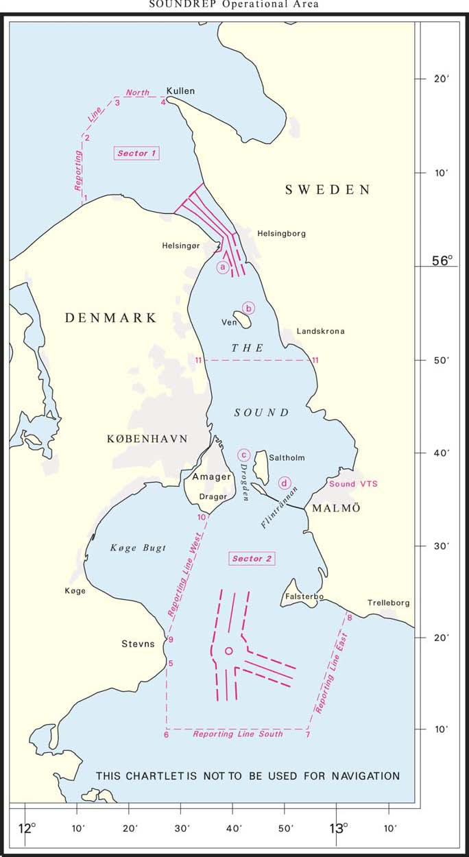
Stk. 3. SOUNDREP indebærer en særlig meldeforpligtelse for skibe, hvis højde overstiger 35 meter, ved passage af Drogden gravede rende, jf. resolutionens nr. 6.6, gengivet i bilag 1. Området for denne meldeforpligtigelse er vist ved kortskitse i bilag 2.
Danske og udenlandske skibe skal overholde meldeforpligtelser, bestemmelser og procedurer i det obligatoriske skibsmeldesystem SOUNDREP, som vedtaget ved resolution MSC.314(88) den 29. november 2010 af den Internationale Maritime Organisation (IMO) gengivet i bilag 1. For så vidt angår forhold omfattet af lov om beskyttelse af havmiljøet henvises til Naturstyrelsens bekendtgørelse om indberetning af oplysninger om farligt gods via skibsmeldesystemet SOUNDREP.
Farvandsvæsenet forestår driften af skibsmeldesystemet SOUNDREP, for så vidt angår det danske søterritorium og den danske eksklusive økonomiske zone.
Stk. 2. Driften af SOUNDREP skal ske under iagttagelse af gældende Vejledning om skibstrafiktjenester (VTS) i danske farvande.
Farvandsvæsenet beslutter, hvorvidt der på baggrund af SOUNDREP’s iagttagelser skal rettes henvendelse til relevante myndigheder med henblik på håndhævelsesmæssige tiltag, eksempelvis hvis skibe overtræder skibsmeldesystemets bestemmelser på dansk søterritorium eller i den danske eksklusive økonomiske zone.
Overtrædelse af § 2 straffes med bøde eller fængsel i indtil 1 år.
Stk. 2. Straffen kan stige til fængsel i indtil 2 år, hvis der
ved overtrædelsen er sket skade på liv eller helbred eller er fremkaldt fare herfor,
tidligere er afgivet forbud eller påbud for samme eller tilsvarende forhold, eller
ved overtrædelsen er opnået eller tilsigtet en økonomisk fordel for den pågældende selv eller andre.
Stk. 3. Der kan pålægges selskaber m.v. (juridiske personer) strafansvar efter reglerne i straffelovens 5. kapitel.
Bekendtgørelsen træder i kraft den 1. september 2011.
Stk. 2. Bekendtgørelse nr. 955 af 13. oktober 2005 om radiomelding ved passage af Drogden gravede rende for skibe hvis højde overstiger 35 m ophæves.
/ Carsten Jensen
Bilag 1
RESOLUTION MSC.314(88)
(adopted on 29 November 2010)
NEW MANDATORY SHIP REPORTING SYSTEM
"IN THE SOUND BETWEEN DENMARK AND SWEDEN" (SOUNDREP)
THE MARITIME SAFETY COMMITTEE,
RECALLING Article 28(b) of the Convention on the International Maritime Organization concerning the functions of the Committee,
RECALLING ALSO regulation V/11 of the International Convention for the Safety of Life at Sea, 1974, as amended (SOLAS Convention), in relation to the adoption of mandatory ship reporting systems by the Organization,
RECALLING FURTHER resolution A.858(20), resolving that the function of adopting ship reporting systems shall be performed by the Committee on behalf of the Organization,
TAKING INTO ACCOUNT the Guidelines and criteria for ship reporting systems adopted by resolution MSC.43(64), as amended by resolutions MSC.111(73) and MSC.189(79),
HAVING CONSIDERED the recommendations of the Sub-Committee on Safety of Navigation, at its fifty-sixth session,
1. ADOPTS, in accordance with SOLAS regulation V/11, a new mandatory ship reporting system "In the Sound between Denmark and Sweden" (SOUNDREP), as set out in annex;
2. DECIDES that the above-mentioned new mandatory ship reporting system will enter into force at 0000 hours UTC on 1 September 2011;
3. REQUESTS the Secretary-General to bring this resolution and its annex to the attention of Contracting Governments to the SOLAS Convention and to members of the Organization.
ANNEX
DESCRIPTION OF THE MANDATORY SHIP REPORTING SYSTEM "IN THE SOUND BETWEEN DENMARK AND SWEDEN" (SOUNDREP)
1 Categories of ships required to participate in the system
1.1 Ships participating in the ship reporting system:
Ships of 300 gross tonnage and upwards proceeding to or from ports or anchorages in the Sound or passing through the reporting area.
Pursuant to SOLAS 1974 Convention, as amended, the SOUNDREP does not apply to warships, naval auxiliaries, other ships owned or operated by a Contracting Government and used, only on Government non-commercial service. However, such ships are encouraged to participate in the reporting system.
2 Geographical coverage of the system and the number and edition of the reference chart used for delineation of the system
2.1 The mandatory ship reporting system SOUNDREP is operated by Sound VTS. The call sign is "Sound Traffic".
2.2 The operational area of SOUNDREP covers the northern, central and southern part of the Sound as shown on the chartlet given in Appendix 1. The area includes the routeing systems, in the north TSS "In the Sound" and in the south TSS "Off Falsterbo", both adopted by the Organization.
2.2.1 Report and border line North
Denmark:
| (1) 56° 06´.58 N | 012° 11´.00 E | (Rågeleje) |
|---|---|---|
| (2) 56° 14´.00 N | 012° 11´.00 E | (At sea North of Rågeleje) |
Sweden:
| (3) 56° 18´.08 N | 012° 17´.39 E | (At sea West of Kullen) |
|---|---|---|
| (4) 56° 18´.08 N | 012° 26´.88 E | (Kullen Light House) |
2.2.2 Report and border line South
Denmark:
| (5) 55° 17´.44 N | 012° 27´.28 E | (Stevns Light House) |
|---|---|---|
| (6) 55° 10´.00 N | 012° 27´.28 E | (At sea South of Stevns) |
Sweden:
| (7) 55° 10´.00 N | 012° 54´.50 E | (At sea South of Falsterbo) |
|---|
2.2.3 Report and border line East
Sweden:
| (7) 55° 10´.00 N | 012° 54´.50 E | (At sea South of Falsterbo) |
|---|---|---|
| (8) 55° 22´.89 N | 013° 01´.93 E | (Fredshög) |
2.2.4 Report and border line West
Denmark:
| (9) 55° 19´.81 N | 012° 27´.30 E | (Mandehoved) |
|---|---|---|
| (10) 55° 33´.28 N | 012° 35´.53 E | (Aflandshage) |
2.2.5 Sector division
The SOUNDREP area is divided into two sectors at latitude 55° 50´.00 N; sector 1 northerly and sector 2 southerly. Each sector has an assigned VHF channel as shown in Appendix 2.
2.3 The reference charts (Datum: World Geodetic System 1984 (WGS 84)), which include the operational area of SOUNDREP, are:
.1 Danish charts Nos. 102 (7th edition May 2009), 104 (5th edition Aug 2009), 131 (1st edition Nov 2008), 132 (19th edition Aug 2009) and 133 (13th edition Sep 2009); and
.2 Swedish charts Nos. 921 (4th edition 2009) and 922 (22th edition 2009).
3 Format, content of reports, times and geographical positions for submitting reports, authority of whom reports should be sent and available services
**3.1 ** Procedures of reporting
3.1.1 The SOUNDREP report must be initiated (see paragraph 3.1.4) to Sound VTS using VHF voice transmission. However, ships can fulfil most of the reporting requirements of the reporting system by the use of non-verbal means such as AIS (Automatic Information System) class A as approved by the Organization, and by e-mail or other alternative methods, prior to entering the ship reporting area (see also paragraph 3.4.1, Note (c)). Additional details are given in Appendix 3. For contact information see Appendix 2.
3.1.2 The use of correct and updated AIS information can accomplish the reporting requirements for designators A (part of), B, C, E, F, I, O, P and W.
3.1.3 E-mail or other alternative methods prior to entering the ship reporting area, can accomplish the reporting requirements for designators L, T and X. Such non-verbal partly report must also state designator A (see also paragraph 3.4.1, Note (c)). Additional details are given in Appendix 3.
3.1.4 A ship which fulfils the reporting requirements of the SOUNDREP mandatory ship reporting system, by the use of non-verbal means, must as a minimum carry out a VHF voice transmission to communicate the name of the ship (part of designator A) and the report line of entry, to the Sound VTS when actually entering the area. The same procedure must be followed before departing a port or leaving an anchorage in the SOUNDREP area. Additional details are given in Appendix 3.
3.1.5 Designators U and Q, if applicable, shall at all times be given using VHF voice transmission to Sound VTS when entering the area. Additional details are given in Appendix 3.
3.1.6 To prevent overloading the VHF channels for reporting by verbal voice transmissions and to avoid interference with essential navigational duties, and by this hampering the safety of navigation in the area, a ship unable to accomplish the reporting requirements for designators L, T and X by e-mail or other alternative methods prior to entering the ship reporting area, can report these designators by the use of radio telephone or mobile phone to Sound VTS. Designator A must additionally be included in this part reporting.
3.2 Verbal reporting is not required when a ship is passing the SOUNDREP sector line at latitude 55° 50´.00 N. However, change of VHF frequency is required according to Appendix 2.
**3.3 ** Format
The mandatory ship report shall be drafted in accordance with the format shown in Appendix 3. The information requested from ships is derived from the Standard Reporting Format shown in paragraph 2 of the Appendix to resolution A.851(20).
**3.4 ** Content
A report from a ship to the SOUNDREP by non-verbal means or by voice transmission must contain the following information:
A Name of the ship, call sign and if available IMO identification number and MMSI No.
B Date and time
C Position expressed in latitude and longitude
E True course
F Speed
I Destination and ETA
L Route information on the intended route through the Sound
O Maximum present draught
P Cargo; and quantity and IMO class of dangerous goods, if applicable (see note (c) below)
Q Defects and deficiencies or other limitations
T Contact details for the communication of cargo information (see note (c) below)
U Air draught when exceeding 35 metres
W Total number of persons on board
X Type and estimated quantity of bunker fuel, for ships of 1,000 gross tonnage and above
Note:
(a) On receipt of a report, operators of the Sound VTS will establish the relation to the ship's position and the information supplied by the facilities available to them.
(b) The master of the ship must forthwith inform the Sound VTS concerned of any change to the information notified, including designator Q.
(c) Information on dangerous cargo and contact details for the communication of cargo information (designator P and T of the reporting format) is only requested when such information has not been notified to the competent authority via SafeSeaNet in an European Union (EU) member State in accordance with the requirements of Article 13 (for ships leaving or entering an EU port) in Directive 2002/59/EC on establishing Community vessel traffic monitoring and information system and amended by Directive 2009/17/EC, prior to entering the operational SOUNDREP area. Additional details are given in Appendix 3.
**3.5 ** Geographical position for submitting reports
3.5.1 Ships entering the SOUNDREP operational area shall submit a report when crossing the entrance lines or on departure from a port or anchorage within the operational area.
3.5.2 Further reports should be made whenever there is a change in navigational status or circumstance, particularly in relation to designator Q the reporting format.
**3.6 ** Crossing traffic
Recognizing that ferries crossing between Helsingør and Helsingborg operate according to published schedules special reporting arrangements can be made on a ship to ship basis. Ferries leaving the ports Helsingør in Denmark and Helsingborg in Sweden operating according to published schedules are normally not requested to report to the Sound VTS.
**3.7 ** Authority
The VTS Authority for the SOUNDREP is Sound VTS with call sign "Sound Traffic". Additional details are given in Appendix 2.
4 Information to be provided to ships and procedures to be followed
4.1 Ships are required to keep a continuous listening watch in the area on the relevant VHF sector channel and VHF channel 16.
4.2 Sound VTS will provide information service to shipping about specific and urgent situations, which could cause conflicting traffic movements as well as other information concerning safety of navigation for instance, information about weather, current, ice, water level, navigational problems or other hazards.
4.2.1 If necessary, Sound VTS can provide individual information to a ship particularly in relation to positioning and navigational information or local conditions by using the IMO Standard Marine Communication Phrases (SMCP), section A1/6 for VTS message markers. The message markers can be of ADVICE, WARNING, INFORMATION, QUESTION, ANSWER, REQUEST and INTENTION.
4.2.2 Information of general interest to shipping in the area will be broadcast by Sound VTS on VHF channel as specified by the VTS operator or will be given on request. A broadcast will be preceded by an announcement on VHF channel 16. All ships navigating in the area should listen to the announced broadcast.
4.3 If a ship needs to anchor due to breakdown, low visibility, adverse weather, changes in the indicated depth of water, etc., Sound VTS can recommend suitable anchorages or other place of refuge within the operational area.
5 Communication required for the SOUNDREP system
5.1 The language used for communication shall be English, using IMO Standard Marine Communication Phrases, where necessary.
5.2 Details of communication and contact information are given in Appendix 2.
6 Rules, regulations and recommendation in force in the area of the system
**6.1 ** Regulations for preventing collisions at sea
The International Regulations for Preventing Collisions at Sea (COLREG) are applicable throughout the operational area of SOUNDREP.
**6.2 ** Traffic separation scheme "In the Sound"
The Traffic separation scheme "In the Sound", situated to the north in the narrows of the Sound, as adopted by the Organization, and rule 10 of the International Regulations for Preventing Collisions at Sea therefore applies.
**6.3 ** Traffic separation scheme "Off Falsterbo"
The separation scheme "Off Falsterbo" situated in the southern part of the Sound, as adopted by the Organization, and rule 10 of the International Regulations for Preventing Collisions at Sea therefore applies.
**6.4 ** IMO Recommendation on Navigation through the entrances to the Baltic Sea – The Sound
SN.1/Circ.263, section 1.9 and IMO publication on Ships' Routeing, part C, on Amendments to Recommendation on Navigation through the entrances to the Baltic Sea, adopted at MSC 83 in October 2007, recommends for the Sound that loaded oil tankers with a draught of 7 metres or more, loaded chemical tankers and gas carriers, irrespective of size, and ships carrying a shipment of irradiated nuclear fuel, plutonium and high-level radioactive wastes (INF Code materials), when navigating the Sound between a line connecting Svinbådan Lighthouse and Hornbæk Harbour and a line connecting Skanör Harbour and Aflandshage should use the pilotage services established by the Governments of Denmark and Sweden.
**6.5 ** Mandatory pilotage
Harbours within the SOUNDREP area are covered by provisions about mandatory pilotage for certain ships bound for or coming from Danish and Swedish ports.
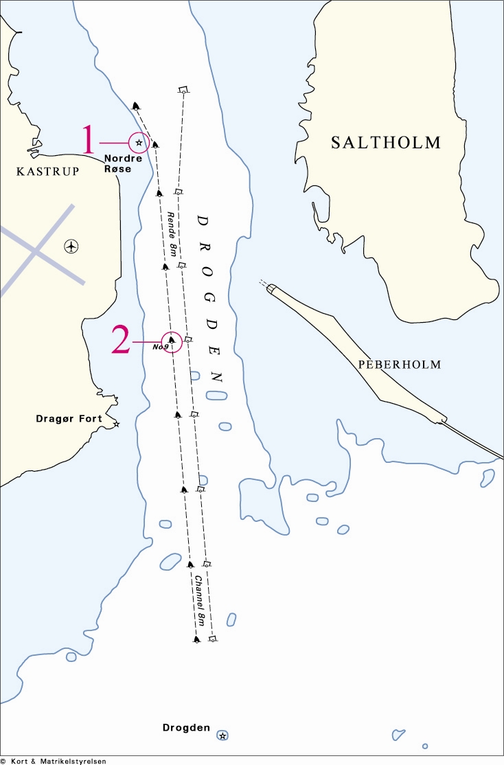
**6.6 ** Air draught when exceeding 35 metres
6.6.1 The navigable Drogden channel is located beside a major airport. In order to ensure safety of navigation in the dredged channel of Drogden and to reduce the risk of collision between an aircraft that serves the airport and a ship or other floating equipment, a reporting obligation has been established. Additional details are given in Appendix 3, designator U.
6.6.2 The safety procedure that has been established is that for all ships, including ships with a tow, with an air draught exceeding 35 metres, Sound VTS shall notify the air traffic control stating the maximum air draught of the ship or floating equipment. The notification shall be given at least 30 minutes prior to the expected time (UTC) for passage of:
.1 Nordre Røse lighthouse at position 55° 38´.17 N, 012° 41´.21 E; and
.2 light buoy No.9 at position 55° 36´.15 N, 012° 41´.79 E.
6.6.3 Sound VTS will transfer the information to the air traffic control.
7 Shore-based facilities to support the operation of the system
**7.1 ** System capability
7.1.1 The Sound VTS centre is situated at Malmö, Sweden.
7.1.2 The Sound VTS system comprises several remote sensor sites. The sites provide surveillance of the SOUNDREP area using a combination of radar and AIS. An integrated network of ten radar sensors integrated with AIS provides surveillance of the area.
7.1.3 All the sensors mentioned below will be controlled or monitored by the VTS operators.
7.1.4 Recording equipment automatically stores information from all tracks, which can be replayed. In case of incidents the VTS authority can use records as evidence. VTS operators have access to different ship registers, pilot information and hazardous cargo data.
7.1.5 An integrated database is available for the operators in handling information.
**7.2 ** Radar and other sensors
Information necessary to evaluate the traffic activities within the operational area of SOUNDREP is compiled via remote controlled sensors comprising:
.1 Sensors for water level and current at Drogden and Flintrännan;
.2 High-resolution radar systems; and
.3 VHF communications systems including DSC call (see Appendix 2).
**7.3 ** Radio communication equipment
Redundant VHF system with DSC functionality (see Appendix 2).
**7.4 ** AIS facilities
Sound VTS is linked to both the Danish and Swedish national shore-based AIS network and can continually receive messages broadcast by ships with transponders to gain information on their identity and position. The information is displayed as part of the VTS system and is covering the ship reporting area.
**7.5 ** Personnel qualifications and training
7.5.1 The VTS centre is staffed with personnel all educated and experienced as officers in charge of navigational watch according to national and international requirements.
7.5.2 Training of VTS personnel will meet the standards recommended by IMO in MSC/Circ.1065 on IALA Standards for training and certification of VTS personnel (Ed. 2).
7.5.3 Refresher training is carried out on a regular basis.
8 Information concerning the applicable procedures if the communication facilities of shore-based Authority fail
8.1 The system is designed with sufficient system redundancy to cope with normal equipment failure.
8.2 In the event of radio communication system failure at the VTS centre, communication will be maintained via a redundant standby VHF system. If the radar system or other essential equipment suffers a breakdown, information of reduced operational capability will be given by Sound VTS or as national navigational warnings.
9 Measures to be taken if a ship fails to comply with the requirements of the system
9.1 The objective of the VTS Authority is to facilitate the exchange of information between the shipping and the shore in order to ensure safe passages of the bridges, support safety of navigation and the protection of the marine environment.
9.2 All means will be used to encourage and promote the full participation of ships required to submit reports under SOLAS regulation V/11. If reports are not submitted and the offending ship can be positively identified, then information will be passed to the relevant flag State Authority for investigation and possible prosecution in accordance with national legislation. Information will also be made available to Port State Control inspectors.
 |
|---|
| Appendix 1 |
Appendix 2
Contact information and assigned VHF channels for sectors in the mandatory ship reporting system
"In the Sound between Denmark and Sweden" (SOUNDREP)
| SOUNDREP, radio call sign | ”Sound Traffic” |
|---|---|
| VHF CHANNELS | Operational use |
| VHF Channel 73 | Sound VTS – Sector 1 North |
| VHF Channel 71 | Sound VTS – Sector 2 South |
| VHF Channel 79 | Sound VTS – Broadcast 1, individual assistance |
| VHF Channel 68 | Sound VTS – Broadcast 2, individual and reserve channel |
The Sound VTS operating SOUNDREP is located in Malmö, Sweden:
H24 contact information:
| 1) Sound VTS is monitoring VHF channels 73, 71 and 16 continuously. | |
|---|---|
| 2) Duty officer phone: | +46 40 20 43 17 or, |
| +46 40 20 43 34 | |
| 3) Fax: | +46 40 20 43 45 |
| 4) E-mail: | contact@soundvts.org |
| Address: | |
| Sound VTS Hans Michelsensgata 9 Box 855 S-201 80 Malmö Sweden |
Appendix 3
Drafting of reports to the mandatory ship reporting system
"In the Sound between Denmark and Sweden" (SOUNDREP)
| Designator | AIS | Function | Information required |
|---|---|---|---|
| A | Yes, and VHF | Ship | Name of the ship (VHF); call sign and if available IMO identification number and MMSI number (AIS) |
| B | Yes | Date and time of event | A 6-digit group event giving day of month and hours and minutes in Universal Co-ordinated Time (UTC). |
| C | Yes | Position | A 5-digit group giving latitude in degrees and minutes, decimal, suffixed with N and a 6-digit group giving longitude in degrees and minutes, decimal, suffixed with E. |
| E | Yes | True course | A 3-digit group |
| F | Yes | Speed in knots and tenths of knoths | A 3-digit group |
| I | Yes | Destination and ETA | The name of next port of call given in UN LOCODE. For details see in IMO SN/Circ.244 and; www.unece.org/cefact/locode/service/main.htm Date and time group expressed as in (B) |
| L | No | Route information | A brief description of the intended route as planned by the master. Ships navigating in The Sound have options on deciding route in the following areas (see Appendix 1); a) Disken shoal b) Ven island c) Drogden channel d) Flintrännan channel The route information should be given coded by using the following local designators: - DW – Disken, west of - DE – Disken, east of - VW – Ven, west of - VE – Ven, east of - D – Drogden - F – Flintrännan See examples below. |
| O | Yes | Maximum present draught in metres | A 2-digit or 3-digit group giving the present maximum draught in metres (e.g.: 6.1 or 10.4) |
| P | Yes | Cargo on board | Cargo; and quantity and IMO class of dangerous goods, if applicable. (see 3.4.1, note c) |
| Q | VHF | Defects and deficiencies or other limitations | Details of defects and deficiencies affecting the equipment of the ship or any other circumstances affecting normal navigation and manoeuvrability. |
| T | No | Ship’s represenative and or owner | Address and particulars from which detailed information on the cargo may be obtained. |
| U | VHF | Ship’s size | Information of maximum air draught when exceeding 35 metres, required for all ships, including ships towing or other floating equipment. This information shall be given by voice transmissions when entering the SOUNDREP area, irrespectively of, if the information also is given by, e.g., AIS; details in paragraph 6.6. |
| W | Yes | Total number of persons on board | State number. |
| X | No | Miscellaneous | Type and estimated quantity of bunker fuel, for ships of 1,000 gross tonnage and above. |
Examples of routes as given under designator L
A northbound ship leaving Malmö Port planning to sail, east of Ven, TSS In the Sound (UN LOCODE format for Malmö Port is SE MMA):
L: SE MMA, VE
A southbound ship in transit planning to sail TSS In the Sound, east of Disken, west of Ven, Drogden channel and TSS Off Falsterbo:
L: DE, VW, D
***
| Noter: |
|---|
| Designator P og T – Resolutionstekstens nr. 3.4.1, note (C):Informationer om ladning og farligt gods samt adresse for oplysninger om ladningen (designator P og T) for den pågældende rejse er krævet, når sådanne informationer ikke tidligere, forud indsejlingen i SOUNDREP-området, er blevet meddelt til den kompetente myndighed. Dette via SafeSeaNet (SSN) i en medlemsstat af den Europæiske Union i overensstemmelse med artikel 13 (for skibe der afgår eller anløber en EU-havn) i Europa-Parlamentets og Rådets direktiv 2002/59/EF, som ændret ved direktiv 2009/17/EF om oprettelse af et trafikovervågnings- og trafikinformationssystem for skibsfarten i Fællesskabet. For at lette rapporterings proceduren anbefales det, at skibe, der medfører farligt gods, informerer om, at dette er meldt via SSN, hvis skibet ikke angiver P og T informationer til SOUNDREP. |
| Designator P – ladning og farligt gods (Appendix 3): Det er i IMO-resolution MSC.314(88) angivet, at ladning og farligt gods kan angives med AIS. De af EU-Parlamentets og Rådets direktiv 2002/59/EF, som ændret ved direktiv 2009/17/EF, krævede oplysninger om ladning og farligt gods kan ikke gives med AIS. Dette gøres i stedet ved e-mail, fax mv., alternativt med VHF ved passage af en meldelinje eller før afgang fra havn eller ankerplads. |
| Designator W – samlede antal personer om bord (Appendix 3): Det er i IMO-resolution MSC.314(88) angivet, at det samlede antal ombordværende kan angives med AIS. Teknisk kan dette imidlertid ikke aflæses med AIS-systemet. Designator W afgives i stedet med e-mail, fax mv., alternativt med VHF ved passage af en meldelinje eller før afgang fra havn eller ankerplads. |
| Designator U – maksimal højde over vandoverfladen i meter: Information om området for meldeforpligtigelsen for skibe, hvis højde overstiger 35 meter, ved passage af Drogden gravede rende er vist ved kortskitse i bilag 2. |
Bilag 2
Officielle noter
